Historic Landscape of Nevada
No description.
Early Settlements & Ranches
Collection Paragraphs
The Las Vegas Springs supported intermittent Native American inhabitation for millennia. The Paiutes often made seasonal encampments at the springs that usually lasted through the winter. The springs were a welcome stop on the Old Spanish Trail, as Spanish then American travelers traveled along the well-worn road.
The Mormons were the first whites to establish settlements in the region. In early 1855, Brigham Young decided to establish missions in present day Utah, Idaho, and Nevada to proselytize the Native Americans, teach them agriculture, and to open a safe road from Salt Lake to the Pacific. 30 missionaries were sent to Las Vegas, led by William Bringhurst. The missionaries experienced initial success, baptizing many, planting crops, and beginning construction on a fort. By 1857, internal tensions and conflict with the local Paiute had already threatened the mission when Brigham Young recalled the missionaries.
Mormon settlers later returned to the Muddy River Valley and settled St. Thomas, Overton, and Logandale, farming and ranching, and using the river to irrigate their fields.
When Hoover Dam began impounding water in February of 1935 forming Lake Mead, some of the earliest settlements disappeared under its waters, including Fort Callville, the head of navigation on the Colorado River; Bonelli’s Ferry at which a ferry operated until the 1920s; and St. Thomas, an agricultural settlement established by Mormon missionaries to grow cotton, which was important enough to warrant a railroad connection to the Salt Lake line in 1910. Also lost under Lake Mead was the Pueblo Grande of Nevada—known as the Lost City—an Anasazi site excavated in 1924, and reconstructed only to be washed away.
Inquiry:
What could justify growing cotton in Southern Nevada and transporting it via rail lines?
Ranching in Southern Nevada, like ranching in the other arid western states, was a hard outdoor life, eking out what would grow in the highly alkaline soil using what water was available and raising what livestock could survive on the scrub that grew near the water on the range.

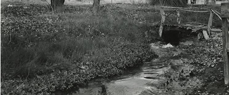
The ranches in the Las Vegas Valley quite naturally grew around the natural springs: the Cottonwood Spring, the Las Vegas Spring, and the small springs that watered what became known as the Kyle Ranch. The land watered by the springs supported fruit orchards, grapes, and a variety of vegetables. Oats, barley, and wheat crops would alternate with beans, melons, squash, cabbage, beets, onions, and potatoes. The grass (in the field, or cut for hay) fed livestock, beef and dairy cattle, horses, and hogs and chickens. Livestock roamed freely on the grasslands, some corralled at night by ranch hands (often local native Americans). Manufactured goods and supplies had to be freighted in from California or Utah.
Inquiry:
Using only images from the collection, how would you characterize desert ranching using the Stewart Ranch as a case study?
The largest and most significant ranch was the Las Vegas Ranch, headquartered on the grounds of the old Mormon mission settlement on the Las Vegas Creek, with grasslands extending west along the creek to where the Las Vegas—or Big Springs—bubbled up from the ground. The ranch later became known as the Stewart ranch after its later owners Archibald Stewart and his wife Helen.
Small Collection Name
Is Nested
Is Double Nested
The Region
Collection Paragraphs
May 3, 1844-- After a day’s journey of 18 miles, in a northeasterly direction, we encamped in the midst of another very large basin, at a camping ground called las Vegas – a term which the Spaniards use to signify fertile or marshy plains . . . Two narrow streams of clear water, four or five feet deep, gush suddenly, with a quick current, from two singularly large springs; these, and other waters of the basin, pass out in a gap to the eastward. The taste of the water is good, but rather too warm to be agreeable . . . they, however, afforded a delightful bathing place.
John C. Fremont, Report of the Exploring Expedition to the Rocky Mountains, 1844
No grass, and difficult to get wood. Water brackish in the Virgin & could get no other . . . Tomorrow hope to reach the Muddy. Has been hot today & road for the most part through heavy sand. Tuesday Oct. 10th, 1848 Started this morning two hours before daylight and made a long march of 35 m. to the “Muddy” & over a very heavy road, without water or grass, by 12 o’clock! We made a delightful camp on a fine stream of water with good grass and found a large body of Indians—Piutes [sic]. From them we bought some corn and beans. And what a meal we made! The valley of “Muddy” is large & land fertile. The water is of the best and purest kind and some day, & that not too distant, this valley will teem with a large & healthy population.
Orvill C. Pratt, Diary, 1848.
A wide expanse of chaotic matter . . . consisting of huge hills, sandy deserts, cheerless, grassless plains, perpendicular rocks, loose barren clay, dissolving beds of sandstone and various other elements, lying in inconceivable confusion—in short, a country in ruins, dissolved by the peltings of the storms of ages, or turned inside out, up side down, by terrible convulsions in some former age. Eastward the view was bounded by vast tables of mountains one rising above another, and presenting a level summit at the horizon, as if the whole country had once occupied a certain level several thousand feet higher than its present and had been washed away, dissolved or sunk, leaving the monuments of its once exalted level smooth and fertile surface. Poor and worthless...
Parley P. Pratt, Report of the Southern Exploring Expedition presented to the legislative council of Deseret, 9 February 1850.
May terminated cold and cloudy although wind strong from the south. Fruit in great quantities and of unusual size. Grapes never better large bunches and well filled unusually large peach trees breaking down with peaches half grown – apricots in large quantities and plumbs -- in every respect an unusually fruitful year & unusually buggy. Everything grows from the very start without trouble, no coaxing is needed this year to make anything grow . . . July 7, Colorado River fell 4 feet no flood this year
O.D. Gass, Las Vegas Ranch Daybook, 1878
With the exception of the arable land of the Muddy, Santa Clara Creek, Pahranagat and Pah-rimp Valleys, and Las Vegas Springs, this section is typical of the desert in all its worst phases. . even the springs found at wide intervals throughout this large area are unreliable, often dry, and that many that were found active when visited are not necessarily permanent . . . the climate is that of the more southerly parts of the Great Basin; i.e. uniform and mild in winter; parching hot in summer . . . The permanent agricultural resources are slight, the grazing considerable, the timber limited, while there is a large field in which to discover and exploit the precious metals.
Captain George Wheeler, U.S. Geographical Surveys West of the 100th Meridian 1889
To describe this country and its sterility for one hundred miles, its gloomy barrenness, would subject the reader’s credulity to too high a strain. Not even the caw of a crow, or the bark of a wolf, was there to break the awful monotony. I could see something green on the tops of the distant mountains, a thousand feet above me, but here there was nothing but a continual stench of miasman, and hot strakes of poisonous air to breathe. Was this Hades, Sheole, or the place for the condign punishment of the wicked, or was it the grand sewer for the waste and filth of vast animation?
George W. Brimhall, The Workers of Utah, 1889
Small Collection Name
Is Nested
Is Double Nested
The Historic Landscape of Nevada: Development, Water, and the Natural Environment
Collection Paragraphs
The persistence of the natural landscape and predominantly arid ecology of Nevada has created one of the greatest challenges facing the people of Nevada and the American West as we struggle to maintain our built environment. This project, The Historic Landscape of Nevada: Development, Water and the Natural Environment, documents the historic role of water resource management in Southern Nevada.
Since the nineteenth century, when the U.S. government first sent scientific expeditions to explore, map, and record the West, a voluminous record has been made of this landscape and the potential to exploit (and sometimes protect) it. Whether through irrigation, ranching, agriculture, dams, railroads, highways, towns, cities, or federal installations, the people of Nevada have challenged the environment in their attempt to make a desert flourish.
From the natural springs that attracted the earliest inhabitants and travelers, to the wells that supported early town development, to the massive federal reclamation projects that dammed the Colorado River to irrigate the California and Arizona deserts, water ruled. With the unparalleled, unexpected, and unplanned growth of the Las Vegas metropolitan area, the development of an urban and regional water system to support it has dominated natural resource planning and exploitation. The basic issues of water use—its quantity, quality, and allocation—still dominate policy and politics in Nevada and the Southwest, as Las Vegas seeks to tap surface and ground water sources in outlying counties and adjoining states, and as the original co-signers of the Colorado River Compact wrangle over the allocations from the dwindling water supplies of Lakes Mead and Powell.
Primary Source Sets for Educators


This collection contains several Primary Source sets designed to immediately connect educators with historical materials. These sets build on the wealth of digitized material in the Historic Landscape of Nevada and can be used to supplement teaching in a wide range of disciplines including: geoscience, math, political science, environmental science, history, and more! Use primary source sets to help reveal the deeper issues and most complex narratives of Nevada's historic landscape.
These sets of digitized images were selected and organized around key themes from the collection and provide educational focal points using five to ten historical documents that relate to a single theme (e.g., “Water Conservation”). Each set includes: a textual overview of the resources within the primary source set and a collection of suggestions for using the primary source set for learner enrichment. Each set also includes a timeline placing the material in historical context and visually representing the events in chronological order.
Choose one of the sets above or see our For Educators page to get started using the collection.