Search Results
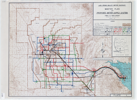
Topographic map of master plan for proposed water supply system for Las Vegas Valley Water District, August 1960
Date
Description
Image

Blueprint map showing proposed changes to water system, Las Vegas Land & Water Co., Las Vegas, Nevada, circa 1936
Date
Archival Collection
Description
Image
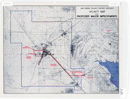
Map showing improvements made to the Las Vegas Valley Water District and vicinity, circa 1950
Date
Description
Image
Las Vegas Land & Water Company Records from the Las Vegas Valley Water District
Identifier
Abstract
The Las Vegas Land & Water Company Records from the Las Vegas Valley Water District (1918-1989) are primarily comprised of contracts, correspondence, and maps that document the establishment of a water distribution system in Las Vegas, Nevada that would provide water using the state's Colorado River allocation. The records include water main extension agreements, correspondence, and bills of sale for water main construction, as well as articles and correspondence documenting the groundwater shortage in Las Vegas. The collection also includes maps for water distribution systems and pipelines throughout the Las Vegas Valley.
Archival Collection

Map showing second stage plan of development for Southern Nevada Water Project, March 1981
Date
Description
Image
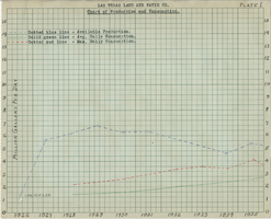
Chart of water production and consumption from the Las Vegas Land and Water Company, 1926-1944
Date
Archival Collection
Description
Chart showing the available production, average daily consumption, and the maximum daily consumption of water from 1926 to 1944
Text

Blueprint showing proposed pipeline for gravity water supply at Las Vegas, Nevada, February 16, 1905
Date
Description
Image
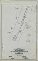
Map showing water connection for jail, Moapa, Nevada, December 28, 1914
Date
Archival Collection
Description
Image
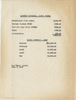
Chart of monthly expenses and water revenue for the Las Vegas Land and Water Company, June 7, 1947
Date
Archival Collection
Description
List of monthly expenses and water revenue for the Las Vegas Land and Water Company for January - May of 1947. Original collection: Union Pacific Railroad Collection 97-19
Text