Search Results

Map showing plan for water quality management update for wastewater collection systems in the Las Vegas Valley, February 20, 1997
Date
1997-02-20
Description
'Plate 1. Source: Clark County Geographic Information Systems Central Repository. Comprehensive Planning, Advanced Planning Division. Feburary 20, 1997.' Scale [ca. 1:95, 040. 1 in.=approx. 1.5 miles]. Shows sewers, force mains, service area boundaries, watershed boundaries, and lift stations. Includes inset location map. Includes township and range grid. Clark County, Nevada, Comprehensive Planning, Advanced Planning Division.
Image
Appraisal of LV water system
Date
1950 to 1951
Archival Collection
Description
Appraisal of LV water system
Text
Maps of water bearing lands
Date
1953 (year approximate)
Archival Collection
Description
Maps of water bearing lands
Image
Working with Water, Dreaming of Water, 2004
Level of Description
File
Archival Collection
Guide to the Canadian Film Centre Worldwide Short Film Festival Submissions
To request this item in person:
Collection Number: MS-00615
Collection Name: Guide to the Canadian Film Centre Worldwide Short Film Festival Submissions
Box/Folder: Box 2004-024
Collection Name: Guide to the Canadian Film Centre Worldwide Short Film Festival Submissions
Box/Folder: Box 2004-024
Archival Component
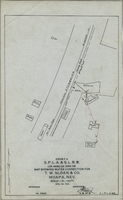
Map showing water connection for T. W. Sloan & Co., Moapa, Nevada, December 28, 1914
Date
1914-12-28
Archival Collection
Description
'Exhibit A.' 'S.P.L.A.&.S.L.R.R., Los Angeles Division.' 'Dec. 28, 1914.' 'Approved, [signed] E.M. Jessup, E.M. of W.' '2-T-168A' hand-printed in lower right corner. Scale: 1 in. = 100 ft.
Image

LVLWC - Las Vegas Valley Water District report on water supply (1 of 2)
Date
1909 to 1954
Archival Collection
Description
Series 2. Las Vegas Land and Water Company -- General Manager, Manager of Properties, and Manager of Industrial Development in Los Angeles, California -- Las Vegas Land and Water Company (LVLWC) Corporate Documents, Reports, and Accounts
Mixed Content
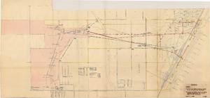
Map showing location of water-bearing lands to be sold to the Las Vegas Valley Water District, March 1, 1953
Date
1953
Archival Collection
Description
'Exhibit A.' 'March 1, 1953.' 'I-128.' Shows location of water-bearing lands to be sold to the Las Vegas Valley Water District and the boundary of lands owned by Union Pacific which are not to be sold to the district. The Union Pacific Railroad Company owned the Las Vegas Land and Water Company. Also shows pipes, proposed pipes, other parts of the water system, power lines, and lists power requirements for water system. Includes township and range lines. Las Vegas Land and Water Company
Image
Report on appraisal of water system owned by LA & SL RR and LV Land & Water Co.
Date
1952
Archival Collection
Description
Report on appraisal of water system owned by LA & SL RR and LV Land & Water Co.
Mixed Content

Water Supply - drilling wells 7 and 8
Date
1920 to 1950
Archival Collection
Description
Series 2. Las Vegas Land and Water Company -- Walter Bracken and the Las Vegas, Nevada Office -- Water Company
Text
American Water Resources Association, Ground Water/Surface Water Interactions, 2002
Level of Description
File
Archival Collection
David Donovan Collection on Hydrology and Geology
To request this item in person:
Collection Number: MS-00813
Collection Name: David Donovan Collection on Hydrology and Geology
Box/Folder: Box 06
Collection Name: David Donovan Collection on Hydrology and Geology
Box/Folder: Box 06
Archival Component