Collection Paragraphs

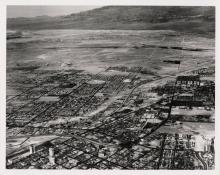
The Las Vegas Artesian Basin lies within the Great Basin and Range geological region. The region is characterized by narrow faulted mountain ranges and flat, arid, valleys or basins. There are extensive maps in this collection showing this distinct geology. The mountains and the bedrock form a rough “V” shape that is filled in with various layers of rock and sediment that form the floor of the valley. The shape of the valley funnels water into an aquifer. Hydrostatic pressure brings this water to the surface mid-valley at the Las Vegas Springs. These springs produced the valley’s namesake. In Spanish, Las Vegas means “the meadows.”

When the route for the SP,LA&SL RR was laid out through the Las Vegas Valley and the right of way acquired by the railroad, the Stewart Ranch with its valuable springs and water rights were purchased by William A. Clark, president of the railroad, as a convenient division point for the railroad and watering stop for its locomotives and trains.
During the construction of the railroad a redwood stave pipe line was laid between the springs and the watering tower on the Las Vegas station grounds. Upon completion of the railroad line the railroad conveyed the ranch lands to its own newly incorporated subsidiary company, the Las Vegas Land & Water Company. After the town was platted and lots sold, the Las Vegas Land & Water Company laid its distribution system of water pipes through the new townsite. These pipes were also made of red wood staves. The Water Company’s system was connected at the edge of the station grounds to the railroad’s water main transmission line from the springs. The Water Company technically purchased it’s water from the railroad.
As the town grew, the supply of water from the springs alone proved inadequate and the water company drilled a series of wells, first in the vicinity of the original three springs, but later at a greater distance west of the springs. By 1954 when the Land & Water Company sold its entire water system to the Las Vegas Water District, it was operating 12 wells.

The water from the springs and wells passed through a settling basin to a reservoir. From the reservoir the water flowed by gravity to the town down an elevation of eighty-one feet over the two mile distance. As the water level of the aquifer which fed the springs was depleted and the supply from the springs declined, the water pressure in the city also declined. To augment water pressure to the city the LVL&W Company eventually installed pumps at its wells and a second main transmission line to the northern part of the city.
From 1905 to 1927 the Water Company only provided water to the original Clark’s Las Vegas townsite. In 1927 a line was extended north from the original transmission line to McWilliams’ original townsite on the west side of the railroad tracks. When developers created new subdivisions beyond the original townsite, water was provided through private water companies usually created for the purpose by the developer, which laid their own pipelines. These private water companies relied either on private wells or connected to the Water Company’s pipelines and purchased their water from the Water Company. As the subdivisions were built out and populated, these private water companies were unable to keep pace, were undercapitalized for construction and maintenance, and often went bankrupt or simply stopped providing service.
Inquiry:
How did procurement of small, privately owned water companies by the Las Vegas Land & Water Company change the fate of water in the Las Vegas Valley and should the Company have overtaken them? Retrospectively, did the procurement of these organization help or hurt the Las Vegas Land and Water Company in the short- or long-term?
The real estate speculation and housing boom associated with the construction of Hoover Dam saw an spread of new subdivisions. In 1928 the Las Vegas Land & Water Co. purchased the water system of the Hawkins Land and Water Company which had provided water to the Hawkins, Bucks, Fairview Subdivisions, and Pioneer Heights. In 1930 the LVL&W Company acquired the Parkview Mutual Water Company, and in 1934 the South Nevada Land & Development Company. In the 1940s the company extended its system to include most of the new subdivisions including the Federal Housing projects that had been built to accommodate the war construction boom. By the end of the war, the entire city—with very few exceptions—was provided with water by the Las Vegas Land & Water Company’s system.
The original pipelines in the city, including those laid by private companies, were mostly of wood stave until 1927 when the LVL&W Co. started replacing pipelines with cast iron pipes. In 1941 all the remaining wooden, as well as older wrought iron pipelines, were replaced by cast iron pipes. Nevada law did not permit customer water meters in cities with populations over 4,500, and the water rates were fixed by the terms of the water company’s franchise with the city of Las Vegas and by the Nevada Public Service Commission (originally at $1.00 a month per house on a 50X150 foot lot) regardless of amount of water used. The rate was increased to $2.00 a month in 1931.
Inquiry:
Since there were few profits from the Las Vegas Land & Water Company, what motivation did the railroad have for keeping it so long?
The Las Vegas Land & Water Company bore the cost of the maintenance and replacement of all its water facilities including pipelines. Considering that the Water Company also had to pay the railroad for all the water it used, its profits were usually negligible. The Union Pacific used the water company largely as a tax write-off.
